

Flood Monitoring
Project Overview
WebCOOS Principal Investigator Dr. Dwayne Porter from University of South Carolina and his team are using camera feeds to monitor flooding or potential flooding from rainfall or tidal events.
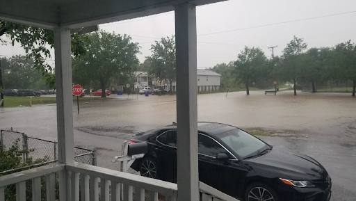 Image of Flooding from the Rosemont Community Camera
Why this Matters
Community flooding resulting from a changing climate, infrastructure modifications, and stormwater management issues impact public health, economic vitality, transportation, etc. Such monitoring can in near real-time provide notification and documentation of these events and be utilized by local interest groups to better understand and remedy flooding issues.
Products
Product Types
- Still images to show flooding
- Trends: number of times camera triggered to turn on for flooding event
How should I use these products?
- Cover monitoring gaps
- Document flooding events
- Alert and inform community members of flooding
- Understand long-term and short-term flooding trends
- Utilize flooding data to support decision making and informing decision makers
What are the limitations?
Storm events may impact both power and connectivity of the instrumentation or communities of interest, impacting the operation or access to products
List of applicable cameras
Resources & Publications
-
Taylor, J., Levine, N.S., Muhammad, E., Porter, D.E., Watson, A.M. and P.A. Sandifer. 2022. Participatory and spatial analyses of Environmental Justice communities’ concerns about a proposed storm surge and flood protection seawall. International Journal of Environmental Research and Public Health. 2022, 19, 19912. https://doi.org/10.3390/ijerph191811192.
-
Python tool to visualize water level data with camera videos: NWLON WebCOOS Synchronizer (Github repository)
Partners
- Lowcountry Alliance for Model Communities
- Charleston Community Research to Action Board
- Rosemont Neighborhood Council
- Center of Excellence for Oceans and Human Health and Climate Change Interactions
- Southeast Water Level Network
- EJ STRONG
- SC Environmental Justice Network

Rip Current Detection
Used to inform public of rip current dangers and issue alerts to lifeguards.
Read more
Shoreline change
Used to identify potential dune erosion or overwash events, infrastructure risk, and limitations to beach access.
Read more
Automated Beach Usage Detection
Provides information to coastal managers on how busy a location is during different times of the day, season, or year for planning purposes.
Read moreFlood Monitoring
Helps to document flooding impacts and provide realtime alerts for local communities.
Read more